- This Is The Score For Your Lab 1 E Maps Of Landscape Regions In The Pacific Northwest Broadly Defined And Several Citi 1 (83.62 KiB) Viewed 15 times
- This Is The Score For Your Lab 1 E Maps Of Landscape Regions In The Pacific Northwest Broadly Defined And Several Citi 2 (46.86 KiB) Viewed 15 times
- This Is The Score For Your Lab 1 E Maps Of Landscape Regions In The Pacific Northwest Broadly Defined And Several Citi 3 (38.76 KiB) Viewed 15 times

- This Is The Score For Your Lab 1 E Maps Of Landscape Regions In The Pacific Northwest Broadly Defined And Several Citi 4 (13.04 KiB) Viewed 15 times
This is the score for your Lab 1 e maps of landscape regions in the Pacific Northwest, broadly defined, and several cities precisely located on one of the maps. See the lab for instructions. Although it does not give the viewer (which includes the grader) as high a quality view of your product as an original copy does, you can submit a map here in digital form if you wish, instead of mailing a hard copy in. Click on "+ Submit Assignment" above right, to do so. If you completed and sent in your landscape region maps, congratulations on your cartographic efforts towards combining geography with geology. The score is based on how well you demonstrate achievement of the following mapping goals: Boundaries between Landscape Regions Boundaries drawn between landscape regions must be accurate (correctly located) and precise (sharp, narrow lines). The two most common types of errors with the boundaries between landscape regions are (1) not drawing them in the correct places, especially along the Coast Ranges, Puget-Willamette Lowland, and Columbia Plateau. (2) Not using narrow, definite lines, but instead using overly thick lines or colored zones, or no lines at all Labels Your name needs to be legible (neatly written, easily read and understood by people who do not know you) at the top of each map page. All landscape region names must clear, easy to read, and make it easy to see which landscape region is which without any effort on map reader's part. All spelling must be correct, which includes appropriate use of capital letters and lower case letters. Cities Each city needs to be precisely plotted (ie. with a small dot) in its correct location relative to where it is on the map and where it is relative to the landscape regions. Each city needs to be properly clearly, neatly labeled (named). The most common errors with the cities are: Each city needs to be precisely plotted (Le, with a small dat in its correct location relative to where it is on the map and where it is relative to the landscape regions. Each city needs to be properly clearly, neatly labeled (named). The most common errors with the cities are: (1) Putting Wenatchee in the Columbia Plateau, when it is actually just inside the boundary of the Cascade Mountains. (2) Not putting Portland in its correct location (it is in the Puget Willamette Lowland, and is not right on the Columbia River). (3) Not putting Seattle on Elliott Bay. (4) Not putting Spokane in its bosin inside of Washington state.
ल
(x assgnlmapgif 14 x nts/assgn1bmap.gif Lab 1 Maps a x PNW Geology Vix
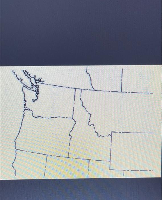
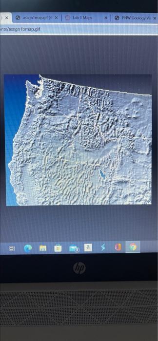
1. Maps of Landscape Regions 1. Print out the map of political boundaries-state outlines man a) On the map, draw outlines of all the Landscape Regions of the Pacific Northwest, and clearly label each of them b) Also on the map, draw a dot at the locations of each of the following cities, and write the name of the city next to the dot Seattle, Portland Wenatchee, Spokane 2. Print out the shaded relief map of the greater Pacific Northwest-relief map a) On the map, draw outlines of all the Landscape Regions of the Pacific Northwest, and label each of them 3 Write your name on each map and mail them to me at